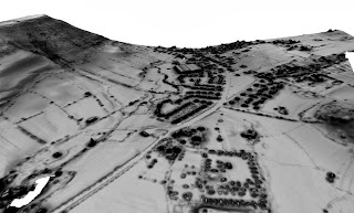
I've been spending a lot of time looking at bare-earth DTMs recently, but this is what leaving in the trees and buildings can do for you. Viewshed analysis of a potential development site showing how much screening the trees, buildings and hedgerows provide. If it's pure black, you can't see any part of the site. Presented here as much for the aesthetic effect (though it might not seem quite so aesthetic if that was your back garden).
The Light of Other Days
Mapping and Archaeology (including quite a lot of Lidar!)
Monday, 19 October 2015
Wednesday, 23 September 2015
Cawthorn Camps, North Yorkshire
Extracted from the newly released EA lidar dataset. Cawthorn camps in North Yorkshire. Something (above) using the Relief Visualization Toolbox and (below) 3D modelling via SAGA.
Tuesday, 15 September 2015
York lidar
The Historic Towns Atlas volume for York would have liked to incorporate a lidar plan, but have unfortunately gone to press too soon. Now that the Environment Agency's restrictive licensing arrangements have given way to an Open Data release they could have used it as they saw fit. Still, here is an image knocked up from the 50cm lidar coverage.
Wednesday, 9 September 2015
Lidar for free!
As of the beginning of this month all of the Environment Agency Lidar data for England has been released as open data. It can be accessed through a new portal. Some have complained of problems, and it can be rather slow loading the background mapping, but I've been able to get my hands on lots of interesting stuff already.
The data is released under Open Government licence which allows commercial use, so it's all there to play with as you see fit. Sadly, in the process we have lost Wales which devolves elsewhere (though through some odd [and yet to be repeated] glitch I managed to download a chunk of the Lleyn peninsula just the other day, so the data seems to be there - hopefully someone will sign it off for release before too long).
Roman temporary camps north and south of Hadrian's Wall just east of Aesica
The data is released under Open Government licence which allows commercial use, so it's all there to play with as you see fit. Sadly, in the process we have lost Wales which devolves elsewhere (though through some odd [and yet to be repeated] glitch I managed to download a chunk of the Lleyn peninsula just the other day, so the data seems to be there - hopefully someone will sign it off for release before too long).
Monday, 1 December 2014
Viking ring forts
Amazingly the danish government has provided open access to lidar survey of the entire country. Of course, I was really hoping to be able to model the Danevirke, but despite the name (and its original function) that now all lies within Germany. However the Viking ring fortresses are rather nice. Here the Aggersborg, Fyrkat and Trelleborg, and below the Aggersborg in 3D.
Only five examples of such fortresses
are known in Denmark. The Nonnebakken fortress at Odense disappeared
beneath the town in the 19th century. The ploughed out remains of a fifth, the Borrering, were long suspected but only recently dated (and not really as 'newly discovered' as some news reports/press releases would have you believe!).
Thursday, 9 January 2014
Burrough Hill Lidar
I was surprised to see EA data at 0.5m centres available for this seemingly random block of Leicestershire countryside until I noticed this. So presumably this derives from the survey commissioned by the University of Leicester, although point density may have been somewhat higher in the original surveys to judge by that nice de-vegetated bare-earth model. Pleasing results from this nonetheless.
The first image is a slope severity plot; the perspective view from the south-west is based on a sky-view factor plot.
Monday, 16 December 2013
Grey Ditch
A blast from the past (but which may become more relevant again in future). Looking south(ish) towards Bradwell from the Hope Valley in Derbyshire. The dark age earthwork Grey Ditch runs across the valley from the left-hand skyline, down across the lower slopes and across the line of the Roman road towards Mich Low on the right hand edge of this view (and probably continuing to cut off the hill saddle just behind). Spent a lot of time in these fields recording the earthwork in detail with EDM (in another life). If I can find the files somewhere, I'll post a comparison (this is from Environment Agency 2m-centred lidar, so the effort with the EDM isn't wasted, yet!).
Subscribe to:
Comments (Atom)


