Showing posts with label iron age. Show all posts

Thursday, 9 January 2014

Burrough Hill Lidar

Burrough Hill lidar slope severity plot
I was surprised to see EA data at 0.5m centres available for this seemingly random block of Leicestershire countryside until I noticed this. So presumably this derives from the survey commissioned by the University of Leicester, although point density may have been somewhat higher in the original surveys to judge by that nice de-vegetated bare-earth model. Pleasing results from this nonetheless.
Burrough Hill lidar sky-view factor plot
The first image is a slope severity plot; the perspective view from the south-west is based on a sky-view factor plot.

Monday, 24 June 2013

Old Sarum

old sarum lidar sky view factor
The Iron Age hillfort and later motte (and cathedral) at Old Sarum, just north of Salisbury, Wiltshire. Environment Agency 0.5m-centred data (this stuff is starting to get impressively detailed) expressed as a sky view factor map with colour ramp.
old sarum lidar sky view factor
And the sky-view-factor plot viewed from the NW as a 3D model.


Wednesday, 29 May 2013

Durobrivae - Credenhill - Kenchester

roman town lidar kenchester credenhill durobrivae
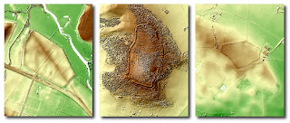
Three lidar images at the same scale: Durobrivae, Credenhill hill fort in Herfordshire and the site of the Roman town at Kenchester a few kilometres to the south. Data courtesy of the Environment Agency again.